GPS tracking reports should help users find an answer without making them wait or separating an alert from the place where it happened. This update improved alert presentation in exports, accelerated address lookup, made map details easier to open, and strengthened the handling of locations received after a delay.
We also added a privacy notice for phone tracking and expanded the H02 protocol with the SIM card's ICCID identifier. Together, these improvements provide clearer information for fleet managers, operators, and installers.
Clearer alerts in exported GPS reports
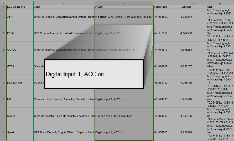
When a report includes the alerts variable, the export now presents the message associated with each location more clearly. Users can connect a position with the detected condition without relying only on codes or references that are difficult to interpret.
This is useful when investigating speeding, zone entry or exit, sensor changes, and other configured rules. The report row retains device, date, and location context while the alert column explains the condition associated with the record.
A readable report reduces the work required for internal reviews, incident sharing with operations, or customer event analysis.
Visual example of alerts in an export
The original image shows how alerts linked with locations appear in the downloaded report.
How to use alert reports
- Select the devices and period to analyze.
- Include date, location, and alert columns required for the report objective.
- Generate the report and review the events with the greatest operational impact first.
- Compare each notification with history, sensors, and location quality.
- Export the result when it needs to be shared or retained as evidence.
An alert indicates that a configured rule was met; it does not explain the cause by itself. Investigation should consider vehicle context, configuration, and received data.
Faster reports with progressively completed addresses
Turning coordinates into street or place names can take longer than loading position, date, and sensor values. To avoid making the whole query wait for every address, Secure GPS can display available rows first and resolve location names progressively.
Users can begin reviewing the report earlier while address cells are completed as information becomes available. This particularly improves the experience for long periods or reports that include many devices.
An address is an interpretation of a coordinate and can vary according to map coverage. For tasks requiring accuracy, retain latitude, longitude, date, and the map link as well.
Benefits of progressive loading
- Faster access to the report's first rows and columns.
- Less initial waiting when many locations are requested.
- Analysis can begin while address names are completed.
- A clearer distinction between a received coordinate and an interpreted address.
Selected details when opening the map
When a location or result opens the map in a new page, Secure GPS displays the selected details directly. Users arrive at the point they wanted to investigate without locating it again among every marker.
This continuity reduces steps between reports and the map. An analyst can identify a relevant row, open it, and immediately review the vehicle, date, sensors, alert, and available geographic context.
We also corrected map scrolling when active alerts are present, allowing users to explore the view without the notification panel interrupting navigation.
Selected map detail demonstration
The original video shows how the selected result appears directly with detailed information.
Consistent handling of old or delayed locations
Some trackers store positions when communication is unavailable or while operating in a power-saving mode, then transmit them later. Those records retain an earlier date even though Secure GPS receives them after newer positions.
We improved the review of these records to detect inconsistencies and maintain a more coherent sequence, especially when sleep states are involved. A historical location should not automatically be interpreted as if it described the vehicle's current state.
This helps history, activity, and calculated conditions better reflect the temporal order reported by the device. It cannot recover data the tracker never recorded, and it does not turn an old position into a real-time reading.
Why a tracker may send locations late
- Temporary loss of mobile coverage.
- Internal storage while the vehicle is in an area without communication.
- Power-saving modes that reduce connection frequency.
- Device restart or recovery after an interruption.
- Tracker configuration that resends historical data.
When interpreting history, always compare the location date with the received time and review the configured reporting frequency.
Privacy notice for GPS phone tracking
The mobile app added a warning message when a phone is used as a tracking device. The notice explains that location will be used and provides context before tracking begins.
This communication helps users understand the function being enabled and addresses app-store requirements. Companies should use phone tracking with authorization, explain its purpose, and comply with rules that apply in their country and employment relationship.
The notice does not replace consent, internal policies, or operating-system permission settings. The phone must grant required permissions and maintain the battery and connectivity conditions needed for reporting.
ICCID identifier for trackers using the H02 protocol
We expanded H02 protocol interpretation to receive the ICCID packet sent by compatible devices. ICCID identifies the installed SIM card and can help connect a tracker with its communication line.
For installers and support teams, this information helps confirm that the expected SIM belongs to the device, document a replacement, or investigate connectivity. Availability depends on the H02 model transmitting the packet in a compatible format.
ICCID alone does not indicate whether a line is active, funded, or within coverage. It is an identifier that should be compared with mobile-operator information and device communication tests.
A real-world case: investigating an alert from a disconnected unit
A manager downloads a weekly report and finds an alert associated with a location. The row is opened on the map, and Secure GPS presents the selected detail directly without requiring another search.
History shows that several positions arrived late after a period without coverage. The manager distinguishes the actual event date and avoids confusing the historical record with the current location. Report addresses continue to complete while other columns are reviewed.
If the device uses H02 and reports ICCID, the installer can compare the SIM identifier with unit documentation before checking the communication line.
Benefits for fleet managers and integrators
- Alerts connected with each location more clearly in exports.
- Earlier analysis while addresses resolve progressively.
- Direct access to a selected detail when the map opens.
- More stable navigation when active alerts are present.
- Better temporal handling of locations transmitted after a delay.
- Greater transparency when a phone is used as a GPS tracker.
- SIM identification on H02 devices that report ICCID.
Technical summary for users and installers
- The alerts variable exports the message associated with a location.
- Report rows can appear before every address name is complete.
- Coordinates and dates remain fundamental references for validating an address.
- The map opens the selected result and keeps its details visible.
- Delayed locations are reviewed according to their date and available states.
- Mobile tracking presents a location-use notice.
- H02 supports ICCID packets in compatible models and formats.
- Availability and quality depend on the tracker, configuration, connectivity, and transmitted data.
Explore GPS reports, alerts, history, maps, and device compatibility in the Secure GPS plans and features.