Secure GPS is a GPS tracking platform for locating vehicles, people, and assets, reviewing route history, managing trackers, and supervising an operation from a map. This update renewed the tracking experience so information uses screen space more effectively, is easier to review on a phone, and arrives more consistently from a broad range of devices.
The improvements cover the GPS map, mobile navigation, each tracker's information panel, public protocol compatibility, the processing of positions stored by devices, platform performance, and service usage control. Together, they make it easier to move from a fleet-wide view to the detail needed for an operational decision.
A Wider GPS Map for Supervising Vehicles and Assets
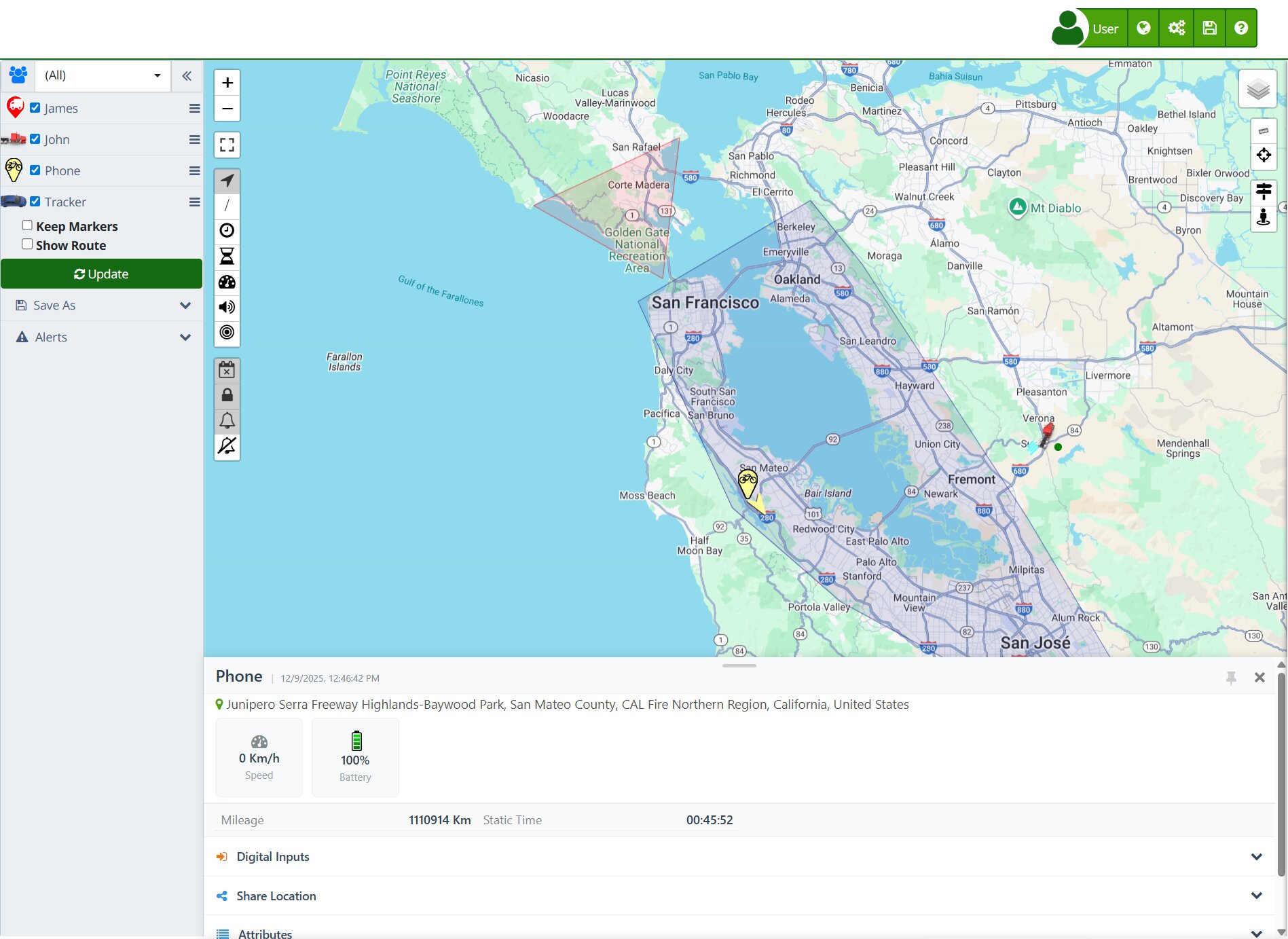
The map is at the center of daily work in Secure GPS: it displays the latest device locations, lets users select markers, and provides access to information about their activity. This version reorganized the interface to reduce unnecessary margins and devote more of the screen to routes and locations.
This is particularly useful when supervising many vehicles, long journeys, or urban areas with several nearby markers. An operator can use the visible area more effectively, recognize positions faster, and keep the geographic context while reviewing a device.
Bottom Navigation Designed for Mobile Use
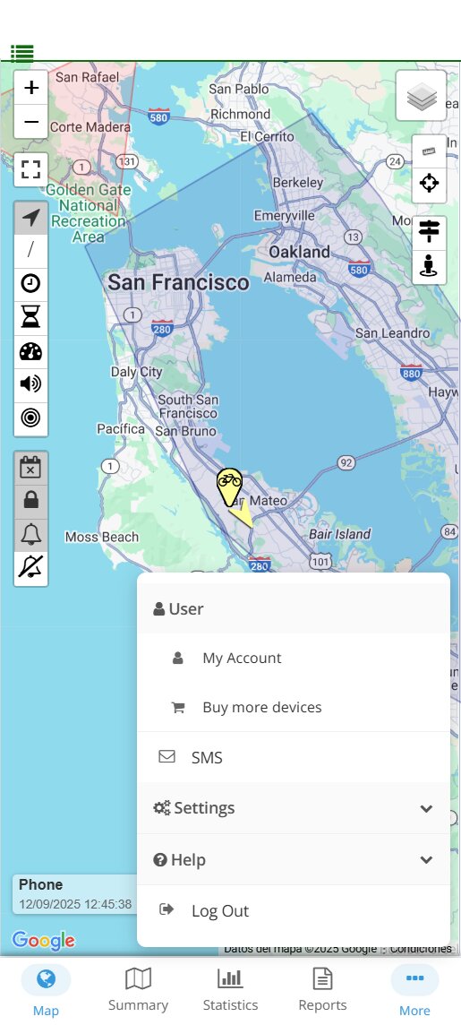
Secure GPS added a bottom menu for phones and small screens. It provides direct access to common sections such as Map, Summary, Statistics, and Reports, plus a menu containing the other options available to the account.
Placing navigation at the bottom reduces movement across the screen and makes one-handed use more comfortable. For a supervisor checking the fleet on the road, during a site visit, or away from the office, this means switching between current tracking and operational analysis in fewer steps.
Device Information Without Leaving the Map
When a marker is selected, tracker information appears in a bottom panel. The panel makes relevant data available without unnecessarily covering the map and can be opened, closed, pinned, or resized according to the space the user needs.
In practice, an operator can keep the vehicle's position visible while reviewing data such as the location time, reported status, and values available for that model. When geographic context must be compared with device information, the user no longer has to choose one view over the other.
Broader GPS Tracker Brand and Model Compatibility
A tracking platform depends on its ability to interpret the information sent by each tracker correctly. Secure GPS expanded and updated its catalog to support more than 100 brands and 1,700 tracker models, giving businesses, integrators, and individual users more options when selecting or reusing hardware.
Compatibility was strengthened across protocol families used by devices such as Teltonika, Ruptela, GT06, GPS103, Suntech, CalAmp, H02, and TRV, among others. For an integrator, this makes it easier to bring devices from different generations or manufacturers into one platform. For the customer, it reduces the need to replace hardware solely to centralize tracking.
Exact availability depends on the model, its configuration, and the functions transmitted by the device. Secure GPS interprets the data supported by each protocol and displays the applicable capabilities in the account.
More Reliable Processing of Incomplete Messages
Mobile networks can split a transmission and deliver it in several parts. If a message is processed before it is complete, a valid position may be incomplete or rejected. This update improved the handling of these cases so the required parts can be received before the packet is interpreted.
The benefit becomes visible in areas with changing coverage, during reconnections, or when certain models send combined messages. Users receive a more coherent history, while technical teams gain a more predictable basis for diagnosing tracker communication.
Stored Locations Ordered in Route History
Many GPS trackers store positions while connectivity is unavailable and send them together after recovering a signal. Secure GPS improved the reading of messages containing multiple locations so their chronological sequence can be analyzed and preserved.
This helps reconstruct the route traveled while the tracker was offline. A transport company can review where a vehicle went even when positions arrived later, a security manager can analyze the sequence of events, and an integrator can validate installed-device behavior more clearly.
Faster Loading and More Stable Communication
The loading of visual resources and the way the interface responds while a page is prepared were also optimized. The goal is to bring users to operational information sooner and make navigation feel smoother on both desktop and mobile devices.
Tracker connections received improvements in validation, message handling, and recovery from partial transmissions. These measures do not change how Secure GPS is used, but they strengthen the continuity with which valid positions can become useful information on the map and in route history.
In a monitoring center, a responsive view and stable workflow matter: they help a team locate a unit, confirm its latest communication, and continue with the next task without unnecessary interruptions.
Usage Notices for Better Account Management
Secure GPS added automatic emails when a device exceeds the permitted request rate or when the account reaches the monthly email-notification limit included in its plan. The notice provides context so an administrator can act before an unsuitable configuration continues to affect the operation.
For example, an integrator can review a tracker transmitting at an unexpected frequency, an administrator can adjust the alert strategy, and a business can evaluate whether its plan matches the real volume of its fleet. Limits depend on the service available to each account and do not change device configuration by themselves.
More Competitive SMS Alert Pricing
Messaging operations were adjusted to offer more competitive prices in destinations where costs had changed. This benefits accounts that use SMS as a complementary alert channel when a notification must reach a phone directly.
The applicable cost can vary by country and destination. Secure GPS displays current information in the corresponding options before the service is used.
Real-World Applications of This Update
- Logistics and distribution: supervise more vehicles on the map, open a unit's information, and reconstruct routes submitted after coverage is restored.
- Security and asset recovery: check the latest position quickly while keeping the map visible as device data is reviewed.
- Technical services and integrators: connect devices from different brands, validate messages, and distinguish a configuration issue from an incomplete transmission.
- Mobile operations: move between Map, Summary, Statistics, and Reports from a phone through more accessible navigation.
- Account administration: identify unusual usage through notices and adjust alerts, reporting frequency, or contracted capacity according to real needs.
How to Start Using the Improvements
The visual functions appear when opening the Secure GPS map from a browser or mobile device. Select a marker to open its information and use the bottom panel to keep the map as a reference. If you manage GPS trackers, confirm that each model is configured with the correct identifier and communication parameters to benefit from the compatibility improvements.
Learn more in the documentation for the Map, Mobile App, Details, device route history, Devices, and email alert sending limits.
Technical Summary for Users and Integrators
- Reorganized map interface with a larger usable tracking area.
- Bottom mobile navigation for Map, Summary, Statistics, Reports, and other authorized options.
- Bottom device-information panel with open, close, pin, and resize controls.
- Public catalog expanded to more than 100 brands and 1,700 GPS tracker models.
- Interpretation improvements across multiple GPS protocol families, including Teltonika, Ruptela, GT06, GPS103, Suntech, CalAmp, H02, and TRV.
- More reliable handling of partial transmissions and messages that contain several locations.
- Chronological ordering of stored positions for more coherent route histories after reconnection.
- Optimized visual loading and general communication-stability improvements.
- Email notices related to request rates and monthly notification limits in the account's plan.
- SMS alert pricing adjustments according to the applicable destination.
With these improvements, Secure GPS delivers a clearer GPS tracking experience for everyday users and a stronger compatibility foundation for the people who install, integrate, or manage tracking devices.