A GPS tracking platform must deliver current positions, turn coordinates into understandable references, and make operational information available for analysis or sharing. This Secure GPS update improves those workflows with a smoother real-time map, faster and more accurate addresses, and more robust Excel exports.
We also optimized general page response, strengthened authorized access from other domains, and moved support meetings to Microsoft Teams. The result is a more efficient experience for operators, fleet managers, analysts, and integrators.
Real-time GPS maps for monitoring vehicles and assets
The Secure GPS map receives locations reported by trackers and displays them as positions that may include speed, heading, date, status, and other compatible data. This view helps users know where a vehicle is, follow its movement, and respond to important changes during an operation.
We reorganized the location update channel to improve the continuity of online tracking. The connection keeps track of the devices each user is monitoring and refreshes its activity while the view remains open, helping deliver new positions to the map more efficiently.
In a logistics control center, for example, a coordinator can keep several vehicles visible, identify which one is approaching its destination, and verify a route change without repeatedly reloading the page. The visible frequency still depends on each tracker's reporting interval, GPS signal, and mobile connection.
Faster and more accurate addresses from GPS coordinates
Reverse geocoding turns latitude and longitude into a readable reference, such as a street, neighborhood, city, or nearby place. This function makes it easier to explain a location, review a stop, or confirm where an event occurred.
We completely updated how these queries are processed and how addresses are composed. Secure GPS can better distinguish elements such as road, number, area, city, region, and country to display a more useful description while retrieving the result more quickly.
A field service manager can use this information to confirm a visit location; a security operator can communicate a unit's reference; and an analyst can understand a route without manually converting every coordinate. Final accuracy depends on the quality of the GPS position and the mapping data available in the area.
Secure GPS reports exported to Microsoft Excel
Exports bring Secure GPS information into a Microsoft Excel file for filtering records, preparing reports, sharing results, or preserving operational evidence. This release optimizes how those files are generated and downloaded.
The process delivers data progressively, handles cancellation more effectively when a user leaves the download, and manages rows, dates, numbers, and text more efficiently. This reduces unnecessary work and improves reliability when a report contains many records.
In practice, a fleet manager can download information for a monthly report, an administrative team can review activity from several devices, and a customer can keep a file compatible with their regular analysis process.
Faster pages and authorized access for integrations
We improved the management of simultaneous requests to distribute work more effectively when several people or Secure GPS functions are active at the same time. External requests and the delivery of resources required to load pages were also optimized.
We also corrected authorized information exchange between domains. For integrators, functions designed to be consumed from a different site can now respond correctly to permitted requests, including the preliminary checks performed by browsers.
These improvements help reduce waiting, prevent loading failures in compatible scenarios, and provide a more stable foundation for portals or tools that use authorized Secure GPS resources. They do not change account permissions: every access remains subject to its applicable validation.
Support meetings through Microsoft Teams
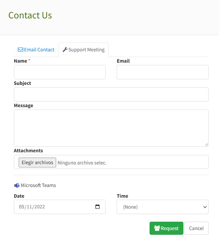
Scheduled meetings with the support team moved to Microsoft Teams. Users can select an available date and time from the contact flow, review their next meeting, and open the meeting link when appropriate.
This option is useful when a case requires reviewing a configuration, guiding an installation, or discussing a situation that is easier to understand in a scheduled conversation. Meeting availability depends on the support options enabled for the account.
Applying these improvements in a real operation
A coordinator can monitor the fleet on the map, use the displayed address to confirm a stop, review activity later, and export the results to Excel. When assistance is needed, the coordinator can schedule a support meeting and share the case context with the Secure GPS team.
For an authorized integration, a technical team can consume available functions from its own environment and confirm that cross-domain requests complete correctly. The same update therefore supports daily operations, analysis, and integration workflows.
Technical summary for users and integrators
- Position delivery to the real-time GPS map and active connection handling were improved.
- Reverse geocoding provides addresses with more useful components and faster queries.
- Excel exports handle progressive writing and download cancellation more effectively.
- Functions authorized for use from other domains respond correctly to compatible requests and preliminary checks.
- Improved simultaneous request management supports better general response for pages and external operations.
- Scheduled support meetings use Microsoft Teams.
Start from the Secure GPS device menu to access tracking and route history, and review Secure GPS plans and features to learn about the capabilities currently available.