GPS alerts should match the decision each operation needs to make. Some conditions require a notification when they begin, while others are more useful when they confirm that the event has ended. This Secure GPS update added an option to notify only when an alert ends, corrected zone and checkpoint evaluation, introduced customizable 3D SVG icons, and expanded JT600 authentication-event support.
The improvements help logistics, security, and fleet teams receive more relevant notices, understand the relationship between a device and a zone, and recognize assets faster on the map.
GPS alerts that notify only when a condition ends
Secure GPS already allowed customers to configure a second notification when an alert stopped being active. This release added another control: Notify only when the alert ends. When selected, the initial notice for that condition is suppressed and the user receives the message defined for its completion.
The setting works together with end-of-alert notification and lets the customer write a specific completion title. This makes it easier to distinguish the potential beginning of an event from confirmation that the condition no longer applies.
A business may only need to know when a vehicle returns to an expected parameter, an idle period ends, or another monitored condition clears. Suppressing the initial notice avoids messages the team does not need and focuses attention on recovery or completion.
The capability provides three practical advantages:
- Fewer irrelevant notices: customers choose whether they need the beginning, the end, or both moments.
- Clearer messages: the completion text can describe the resolved condition.
- Better process alignment: the notice arrives when the responsible person must close, document, or continue a task.
Secure GPS continues to evaluate the condition. The option changes the visible notification moment; it does not turn the alert into a different event or modify data sent by the tracker.
How to use end-of-event notifications
A supervisor can enable notification when an alert ends, enter a title describing the recovery, and select Notify only when the alert ends. Channels, schedules, and recipients depend on the options available for the account.
One example is temperature monitoring. If the operations team only needs confirmation that a reading returned to the expected range, it can receive the completion notice without an additional initial notification. Another example is a vehicle that temporarily stops meeting a movement or location condition and whose manager needs to record when the situation returns to normal.
Customers should verify what beginning and completion mean for the selected alert type. For critical security alerts, suppressing the initial notice may not be appropriate; the decision should follow the customer's response procedure.
More reliable allowed zones, prohibited zones, and checkpoints
Secure GPS geofences compare a device location with areas defined by the user. An allowed zone helps monitor whether an asset remains where it should; a prohibited zone identifies entry into a restricted place; and a checkpoint recognizes passage through an operational location.
This release corrected the evaluation used for allowed and prohibited zones, routes, areas, and checkpoints. It also ensured that activated-area information was retained without duplicates and could be consulted consistently during live tracking and history review.
For customers, the change reduces the risk of incorrectly interpreting whether a reported location belongs to the configured zone. A delivery company can confirm passage through a distribution center, an equipment operator can supervise an authorized work area, and a security business can detect entry into a restricted perimeter.
Results still depend on location quality, zone shape, and tracker reporting frequency. A calculation correction cannot remove natural GPS variation, so geofences should use margins appropriate for the operation.
3D SVG icons with customizable colors
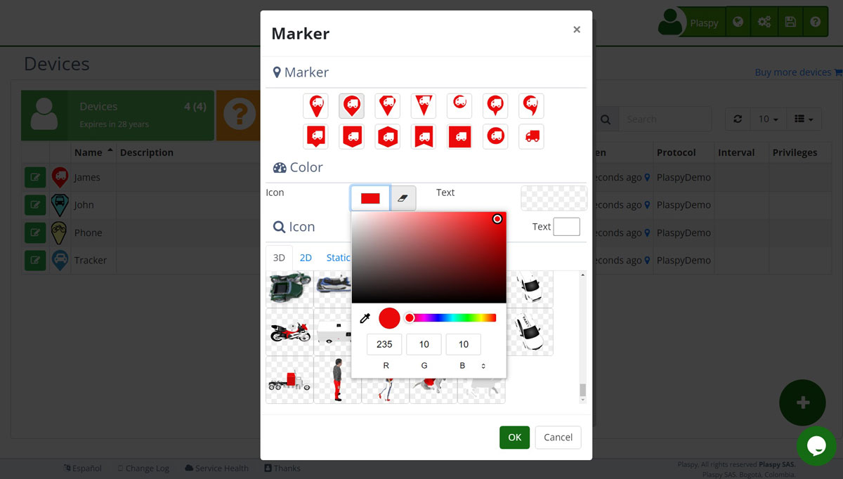
Secure GPS introduced 3D SVG icons that represent devices from different orientations and let users select primary and secondary colors. Vector images remain sharp at different zoom levels and can match the customer's visual identity.
A 3D icon uses several views of the asset. When the tracker reports a course, Secure GPS can display the corresponding orientation on the map. Operators can understand where a vehicle is heading without first opening its details.
Configurable colors let one shape serve different groups. A fleet can distinguish company vehicles from contractors or separate delivery, maintenance, and supervision units without uploading a new design for every group.
Search inside selection lists
Long Secure GPS selection lists gained search. Users can type part of the required value instead of manually scrolling through every option, especially when choosing countries, time zones, and other extensive catalogs during account or subuser setup.
This reduces selection errors and speeds up administrative work. For an organization with operators in several countries, finding the correct time zone also helps display alert dates and schedules consistently for each user.
New JT600 authentication and unlock event
Support for JT600 trackers was expanded to interpret an authentication and unlock report. On compatible models, the event can include the unlock source, RFID identifier, password-verification result, incorrect-password indicator, and associated position.
For integrators and businesses using RFID locks or trackers, this preserves more event context in Secure GPS. Customers can relate the credential involved, the location, and the outcome reported by the device, according to the data available from the installed model.
The tracker also receives the confirmation expected for that report type, completing the public protocol exchange. Field availability depends on firmware, configuration, and the JT600 variant.
Faster delivery of visible resources
Delivery of interface files was optimized to reduce unnecessary work during page loading. The expected benefit is faster presentation of styles, controls, and images, particularly on connections where every additional resource affects waiting time.
This adjustment complements the visible features in the release but requires no user action and does not change device configuration.
More control over when and how a GPS event is interpreted
The release combines notification control, reliable geofence behavior, visual customization, and hardware compatibility. Customers can receive only an alert's completion, classify zones more consistently, find options faster, and represent devices with 3D icons suited to their operations.
Current availability depends on the plan, permissions, and tracker compatibility. Explore Secure GPS plans and features to review the capabilities offered today.