Quickly identifying each vehicle or asset is essential when a map contains many GPS trackers. This Secure GPS update expanded custom device icons with flat, rotating, and 3D options in PNG and SVG formats, and enabled users to upload their own designs.
The improvement helps transportation, logistics, security, and vehicle-rental businesses adapt the map to their operations. Instead of recognizing devices only by name, operators can use a visual representation that matches the vehicle type, asset category, or company identity.
What GPS tracker icons do on the Secure GPS map
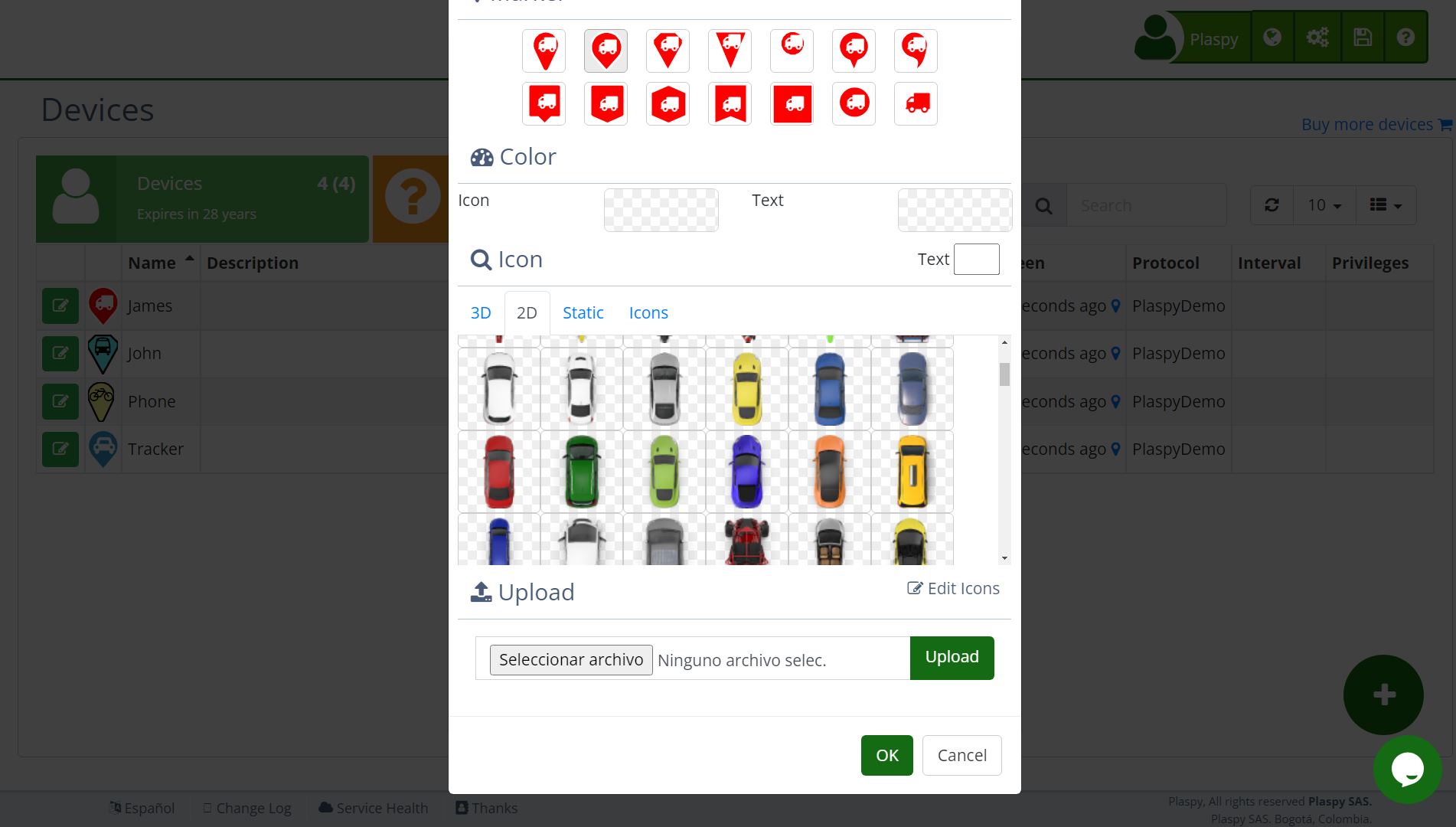
Each Secure GPS device can appear on the map with a marker. The icon accompanies the location received from the tracker and makes the device easier to find among other units. When the selected icon supports rotation, its orientation can also help users interpret the reported course.
This release expanded the available choices so the marker can match both the customer's visual style and the behavior it needs to display:
- Flat PNG icon: a fixed image for logos or illustrations with predefined colors.
- Flat SVG icon: a vector marker that stays sharp at different zoom levels and supports color options.
- Rotating PNG icon: a 2D image that turns to represent device orientation.
- Rotating SVG icon: a vector option that combines direction with configurable colors.
- 3D PNG icon: several views of an asset that change according to its orientation.
- 3D SVG icon: a view-based representation with vector clarity and customization.
The visible direction depends on the course data transmitted by the tracker. If the device does not report orientation, the icon cannot display a new direction.
When to use flat, rotating, or 3D tracker icons
Flat icons work well when the primary purpose is category recognition. A company can use one symbol for cars, another for motorcycles, and another for machinery without needing to show where each asset is pointing.
Rotating icons add orientation to a single design. They help monitoring centers quickly recognize whether a vehicle is heading north, turning inside a yard, or changing direction on a route.
3D icons use different views of the vehicle or asset to present orientation more visually. Rather than rotating one image, Secure GPS selects the view that matches the available course. This can make map reading feel more natural for cars, trucks, and specialized equipment.
How to upload custom PNG or SVG icons
Authorized users can upload their own icons from the marker management area. The workflow lets them select the icon type, assign a name, and provide the file required for that category.
A flat or rotating icon uses its corresponding compatible file. For a 3D representation, the user supplies the requested orientations so Secure GPS can change views as the reported course changes. The platform validates that the file format matches the selected type.
When preparing a design, customers should:
- choose PNG when the exact appearance and colors must remain fixed;
- choose SVG for sharp scaling and configurable colors;
- keep consistent margins across all views of a 3D icon;
- use a shape that remains readable at small sizes and has sufficient contrast;
- assign a descriptive name so the marker is easy to find during device setup.
Configurable colors for vector icons
SVG icons can use primary and secondary colors selected in Secure GPS. One design can therefore serve several groups without requiring a separate uploaded file for every combination.
A delivery company can use the same van shape with one color for company-owned vehicles and another for contractors. A security operator can distinguish units by region or purpose while maintaining a consistent visual identity.
PNG files retain their original colors. They are suitable when an image already contains details, shading, or brand elements that should not change.
Real-world uses for custom GPS map icons
In a mixed fleet, custom markers reduce the effort required to locate an asset. A supervisor can recognize a truck, motorcycle, or machine by its shape before opening the device details.
On a branded tracking platform, icons help the map preserve the visual identity presented to customers. They can also represent operational categories such as delivery, assistance, maintenance, or security when the convention is clear to every user.
Icons do not change GPS location or accuracy. Their value is in presenting the received information more clearly, improving navigation between devices, and supporting faster monitoring decisions.
How icons complement real-time GPS tracking
The Secure GPS map brings together device position, name, and available status. Custom icons add a visual reference and, with rotating or 3D types, represent the course reported by the tracker.
For the best result, customers should assign the right icon to each device, check its appearance at different zoom levels, and confirm that the tracker reports a valid course. Available administration options may depend on the plan, permissions, and branded interface.
A GPS map that is easier to recognize
With PNG and SVG support, flat views, rotation, and 3D representations, Secure GPS lets customers build clearer maps that match their operations. Uploading a custom icon turns the marker into an organizational tool rather than a decorative element.
Explore Secure GPS plans and features to review the tracking and customization options available today.